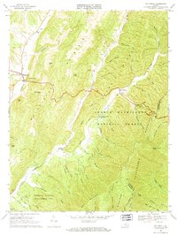
1969 Map of Mc Dowell
USGS Topo · Published 1971About this map
McDowell sits at the western edge of this Highland County landscape, where Bullpasture River and Crab Run meet beneath the heights of Bullpasture Mountain. The 1969 terrain is defined by the high, parallel ridges of the George Washington National Forest and the Shenandoah Mountain, creating a network of deep hollows and drafts. This survey captures a rural Appalachian environment where small settlements like Head Waters and Liberty are connected by winding roads and a mountain Jeep Trail. Notable local institutions include the Hiner Ch and the Columbia Union College Biological Station, while the Highland Wildlife Management Area occupies the southwest corner. The map traces the upper reaches of the Cowpasture River, revealing a remote mountain economy reliant on these narrow river valleys and the seasonal timber and wildlife resources of the surrounding peaks.
Find a feature on this map
60 named features on this map. Tap any name to fly to it.
Don’t see what you’re looking for? This feature index may not catch every label — zoom into the map to look around manually.
Map Details
Editions of this 1969 Mc Dowell Map
2 editions found
Other maps of this area

1894 · Staunton
USGS Topo · 1:125,000

1901 · Monterey
USGS Topo · 1:125,000

1924 · Mc Dowell
USGS Topo · 1:62,500

1941 · Monterey
USGS Topo · 1:62,500

1943 · Craigsville
USGS Topo · 1:62,500

1944 · Monterey
USGS Topo · 1:62,500

1944 · Mc Dowell
USGS Topo · 1:62,500

1945 · Craigsville
USGS Topo · 1:62,500

1946 · Mc Dowell
USGS Topo · 1:62,500

1946 · Williamsville
USGS Topo · 1:62,500