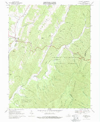
1969 Map of Mc Dowell
USGS Topo · Published 1989About this map
McDowell sits at the western foot of Bullpasture Mountain where Crab Run joins the Bullpasture River, serving as a focal point for this 1969 survey of Highland County. The landscape is defined by parallel ridges including Shaws Ridge and Shenandoah Mountain, creating a drainage pattern of countless drafts and prongs. Near the center of the sheet, the Columbia Union College Biological Station is situated along the Cowpasture River, illustrating the area's scientific and educational value within the George Washington National Forest. Small settlements like Head Waters and Liberty anchor the rural valleys, while family names are preserved through landmarks such as Hiner Ch and Sittlington Hill. In the south, the Highland Wildlife Management Area covers a significant portion of the river bottom, indicating a shift toward conservation and public land management in the late twentieth century.
Find a feature on this map
59 named features on this map. Tap any name to fly to it.
Don’t see what you’re looking for? This feature index may not catch every label — zoom into the map to look around manually.
Map Details
Editions of this 1969 Mc Dowell Map
2 editions found
Other maps of this area

1894 · Staunton
USGS Topo · 1:125,000

1901 · Monterey
USGS Topo · 1:125,000

1924 · Mc Dowell
USGS Topo · 1:62,500

1941 · Monterey
USGS Topo · 1:62,500

1943 · Craigsville
USGS Topo · 1:62,500

1944 · Monterey
USGS Topo · 1:62,500

1944 · Mc Dowell
USGS Topo · 1:62,500

1945 · Craigsville
USGS Topo · 1:62,500

1946 · Mc Dowell
USGS Topo · 1:62,500

1946 · Williamsville
USGS Topo · 1:62,500