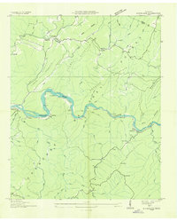
1936 Map of Mc Farland
USGS Topo · Published 1936About this map
The Hiwassee River winds through the heart of the Cherokee National Forest in this 1936 survey, tracing a deep mountain valley marked by tight river bends and sharp elevation changes. The Louisville and Nashville railroad follows the southern bank of the river, connecting small riverside settlements such as Reliance, Hiwassee, and McFarland. These communities, along with northern hamlets like Springton and Servilla, reveal a landscape where transportation and industry were dictated by the rugged contours of Towee Mountain and the Unicoi Mountains. Cultural landmarks such as Maggies Mill and Towee Ch indicate a established rural life before the mid-century expansion of regional infrastructure. The presence of Graveyard Ridge and various gaps like Kirkland Gap suggest traditional travel routes through the high ridges of the Tennessee backcountry during the Depression era.
Find a feature on this map
56 named features on this map. Tap any name to fly to it.
Don’t see what you’re looking for? This feature index may not catch every label — zoom into the map to look around manually.
Map Details
Editions of this 1936 Mc Farland Map
This is the sole edition of this map. No revisions or reprints were ever made.
Other maps of this area

1886 · Cleveland
USGS Topo · 1:125,000

1892 · Cleveland
USGS Topo · 1:125,000

1893 · Murphy
USGS Topo · 1:125,000

1895 · Cleveland
USGS Topo · 1:125,000

1901 · Cleveland
USGS Topo · 1:125,000

1914 · Murphy
USGS Topo · 1:125,000

1934 · Mecca
USGS Topo · 1:24,000

1934 · Tellico Plains
USGS Topo · 1:24,000

1935 · Tellico
USGS Topo · 1:48,000
1935 · Oswald Bald
USGS Topo · 1:24,000