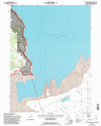
1993 Map of Mc Ginty Point
USGS Topo · Published 1996About this map
Goose Lake dominates this 1990s landscape, its northern shoreline defined by vast stretches of Mud and a prominent Causeway cutting across the shallows. The map highlights the intersection of public and tribal lands, illustrating the boundary of the XL Ranch Indian Reservation as it meets the Modoc National Forest near the water's edge. To the south, agricultural and ranching signatures appear along the periphery of the lake basin, including the Lakeshore Ranch and specialized infrastructure like Feeding Pens near Davis Creek.
Find a feature on this map
24 named features on this map. Tap any name to fly to it.
Don’t see what you’re looking for? This feature index may not catch every label — zoom into the map to look around manually.
Map Details
Editions of this 1993 Mc Ginty Point Map
This is the sole edition of this map. No revisions or reprints were ever made.
Other maps of this area

1886 · Alturas
USGS Topo · 1:250,000

1892 · Alturas
USGS Topo · 1:250,000

1954 · Alturas
USGS Topo · 1:250,000

1958 · Alturas
USGS Topo · 1:250,000

1962 · Alturas
USGS Topo · 1:250,000

1962 · Davis Creek
USGS Topo · 1:62,500

1962 · Big Sage Reservoir
USGS Topo · 1:62,500

1962 · Willow Ranch
USGS Topo · 1:62,500

1962 · South Mountain
USGS Topo · 1:62,500

1965 · Alturas
USGS Topo · 1:250,000