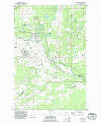
1990 Map of Mc Kenna
USGS Topo · Published 1995About this map
The Nisqually River serves as the prominent natural boundary between Pierce and Thurston Counties, carving a winding path through the center of this 1990s-era landscape. To the north, the Fort Lewis Military Reservation dominates the terrain, featuring the small settlement of Muck City and several lookout towers overseeing the military grounds. The residential and commercial hub of Yelm sits on the western edge of the wide Yelm Prairie, while the town of McKenna is positioned directly along the riverbank, showing evidence of early industry through noted ruins. The map captures a transition from organized military zones and growing towns to the open stretches of Smith Prairie. Local history is preserved in the family-named roads like Hannus Road and Pringle Road, alongside small water bodies such as McKenzie Lake and Crystal Spring.
Find a feature on this map
47 named features on this map. Tap any name to fly to it.
Don’t see what you’re looking for? This feature index may not catch every label — zoom into the map to look around manually.
Map Details
Editions of this 1990 Mc Kenna Map
This is the sole edition of this map. No revisions or reprints were ever made.
Other maps of this area

1897 · Tacoma
USGS Topo · 1:125,000

1900 · Tacoma
USGS Topo · 1:125,000

1916 · Chehalis
USGS Topo · 1:125,000

1937 · Eatonville
USGS Topo · 1:125,000

1940 · Anderson Island
USGS Topo · 1:62,500

1941 · Tanwax Lake
USGS Topo · 1:62,500

1941 · Tacoma South
USGS Topo · 1:62,500

1944 · Tacoma South
USGS Topo · 1:62,500

1944 · Yelm
USGS Topo · 1:62,500

1944 · Ohop Valley
USGS Topo · 1:62,500