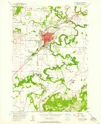
1957 Map of Mc Minnville
USGS Topo · Published 1958About this map
Mc Minnville serves as the focal point of this Yamhill County survey, where the Yamhill River and South Yamhill River meander through a landscape defined by both agriculture and emerging industry. The mid-century city core is dense with civic infrastructure, including the Court House, City Hall, and several educational institutions like Adams Sch and the High School. Outside the city limits, the Southern Pacific railroad facilitates local commerce, connecting the main hub with smaller communities such as St Joseph to the north and Whiteson to the south. The presence of a Sawmill and numerous gravel pits suggests a robust resource-based economy. To the south, the Amity Hills and Walnut Hill rise above the river valley, while established family and community sites like Evergreen Memorial Park and the Mcminnville Grange Hall anchor the rural outskirts.
Find a feature on this map
46 named features on this map. Tap any name to fly to it.
Don’t see what you’re looking for? This feature index may not catch every label — zoom into the map to look around manually.
Map Details
Editions of this 1957 Mc Minnville Map
3 editions found
Other maps of this area

1924 · Mc Minnville
USGS Topo · 1:48,000

1926 · Mc Minnville
USGS Topo · 1:62,500

1940 · McMinnville
USGS Topo · 1:62,500

1941 · Yamhill
USGS Topo · 1:62,500

1942 · Sheridan
USGS Topo · 1:62,500

1942 · Yamhill
USGS Topo · 1:62,500

1942 · Fairdale
USGS Topo · 1:62,500

1948 · Vancouver
USGS Topo · 1:250,000

1950 · Vancouver
USGS Topo · 1:250,000

1950 · Vancouver
USGS Topo · 1:250,000