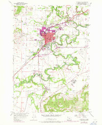
1957 Map of Mc Minnville
USGS Topo · Published 1971About this map
McMinnville serves as the hub of this Yamhill County landscape, characterized by the winding path of the South Yamhill River and its confluence with the Yamhill River. The 1970 revisions, shown in purple, highlight the growth of the urban area around Linfield College and the local High School. The infrastructure of the era is well-defined, from the Southern Pacific rail lines to the McMinnville Municipal Airport on the eastern edge of the Prairie.
Find a feature on this map
49 named features on this map. Tap any name to fly to it.
Don’t see what you’re looking for? This feature index may not catch every label — zoom into the map to look around manually.
Map Details
Editions of this 1957 Mc Minnville Map
3 editions found
Other maps of this area

1924 · Mc Minnville
USGS Topo · 1:48,000

1926 · Mc Minnville
USGS Topo · 1:62,500

1940 · McMinnville
USGS Topo · 1:62,500

1941 · Yamhill
USGS Topo · 1:62,500

1942 · Sheridan
USGS Topo · 1:62,500

1942 · Yamhill
USGS Topo · 1:62,500

1942 · Fairdale
USGS Topo · 1:62,500

1948 · Vancouver
USGS Topo · 1:250,000

1950 · Vancouver
USGS Topo · 1:250,000

1950 · Vancouver
USGS Topo · 1:250,000