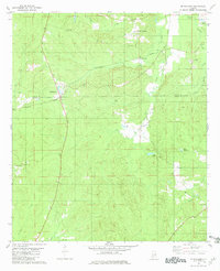
1981 Map of Mc Williams
USGS Topo · Published 1981About this map
McWilliams serves as a central point in this part of southern Alabama, where the landscape is defined by the winding paths of Bear Creek and Grindstone Creek. The map documents a rural corridor at the border of Wilcox Co Monroe Co, where small settlements like Schuster and Ruthven were once linked by the Louisville and Nashville Railroad Grade. The survey reveals a community anchored by local landmarks such as Mt Olive Ch and Hopewell Cem, reflecting the area's genealogical and social history. Toward the eastern edge, the terrain levels out around Lake Jane and Lake Patrick, while the presence of an Old Railroad Grade suggests an evolving transportation network as timber and agricultural patterns shifted in the late twentieth century. These details provide a clear view of the rural infrastructure near Pine Apple and Old Texas as it existed in the mid-1970s.
Find a feature on this map
25 named features on this map. Tap any name to fly to it.
Don’t see what you’re looking for? This feature index may not catch every label — zoom into the map to look around manually.
Map Details
Editions of this 1981 Mc Williams Map
This is the sole edition of this map. No revisions or reprints were ever made.
Other maps of this area

1953 · Andalusia
USGS Topo · 1:250,000

1957 · Andalusia
USGS Topo · 1:250,000

1967 · Beatrice
USGS Topo · 1:24,000

1971 · Skinnerton
USGS Topo · 1:24,000

1971 · Bethel
USGS Topo · 1:24,000

1971 · Beatrice
USGS Topo · 1:24,000
1981 · Rosebud
USGS Topo · 1:24,000
1981 · Oak Hill
USGS Topo · 1:24,000

1981 · Pine Apple North
USGS Topo · 1:24,000
1981 · Nadawah
USGS Topo · 1:24,000