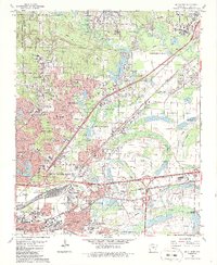
1986 Map of McAlmont
USGS Topo · Published 1986About this map
Camp Joseph T Robinson, home of the Arkansas National Guard, dominates the northwestern corner of this Pulaski County landscape as it appeared in the mid-1980s. The region is defined by rapid suburban growth and a complex network of water and infrastructure. The expansion of Sherwood and North Little Rock is evident through dense residential street grids and commercial landmarks like the Drive-in Theater and North Hills Country Club. The Sherwood corporate boundary weaves through a landscape dotted with numerous small lakes and ponds, including Peeler Lake and Indianhead Lake.
Find a feature on this map
104 named features on this map. Tap any name to fly to it.
Don’t see what you’re looking for? This feature index may not catch every label — zoom into the map to look around manually.
Map Details
Editions of this 1986 McAlmont Map
3 editions found
Other maps of this area

1891 · Little Rock
USGS Topo · 1:125,000

1893 · Little Rock
USGS Topo · 1:125,000

1935 · Mc Almont
USGS Topo · 1:24,000

1935 · Little Rock
USGS Topo · 1:24,000

1935 · Sweet Home
USGS Topo · 1:24,000

1935 · North Little Rock
USGS Topo · 1:24,000

1935 · Alexander
USGS Topo · 1:48,000

1941 · Alexander
USGS Topo · 1:62,500

1941 · Olmstead
USGS Topo · 1:31,680

1941 · Cabot
USGS Topo · 1:31,680
Featured Places
- North Little Rock, AR
- Jacksonville, AR
- Sherwood, AR
- Lakewood, North Little Rock
- Millers Crossing, Sherwood