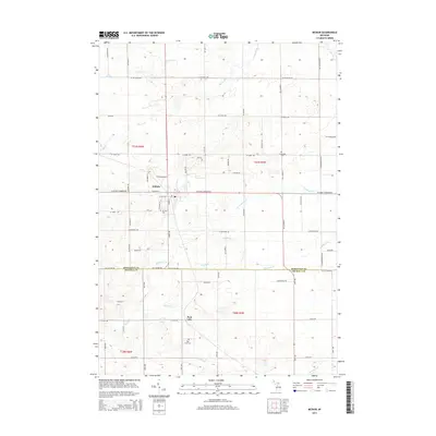
2014 Map of McBain
USGS Topo · Published 2014About this map
McBain serves as the primary hub of this northern Michigan landscape, situated at the junction of W Stoney Corners Rd and S Pine St. The topography is defined by a dense network of waterways, with the Clam River winding through the northern sections while Middle Br Cr and Ryan Cr drain the central and southern reaches. Local history is anchored by established sites like Mt View Cem just south of the main settlement and the community of Park Lake further south, which sits adjacent to its namesake Park Lake and the Park Lake Cem. The transition across the Missaukee Co and Osceola Co line highlights the rural development of the region, where a structured grid of county roads such as 70th Ave and W Meyering Rd connects outlying agricultural lands and small settlements like Riverside to the west.
Find a feature on this map
54 named features on this map. Tap any name to fly to it.
Don’t see what you’re looking for? This feature index may not catch every label — zoom into the map to look around manually.
Map Details
Editions of this 2014 McBain Map
This is the sole edition of this map. No revisions or reprints were ever made.
Other maps of this area

1954 · Traverse City
USGS Topo · 1:250,000

1956 · Cadillac North
USGS Topo · 1:62,500

1956 · Lake City
USGS Topo · 1:62,500

1957 · Cadillac South
USGS Topo · 1:62,500

1957 · Marion
USGS Topo · 1:62,500

1958 · Traverse City
USGS Topo · 1:250,000
1983 · Dighton
USGS Topo · 1:25,000

1983 · Cadillac
USGS Topo · 1:100,000
1983 · Temple
USGS Topo · 1:25,000

1983 · Lake City
USGS Topo · 1:25,000