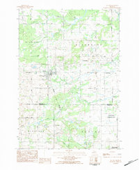
1983 Map of McBain
USGS Topo · Published 1984About this map
McBain serves as the primary center of activity for this agricultural and timbered region of Northern Michigan in the early 1980s. The landscape is defined by the intersection of several townships including Richland, Riverside, Highland, and Marion, where a grid of rural roads like Stoney Corner Road and Vander Meulen Road connect isolated farmsteads and community landmarks. The hydrological network is dominated by the Clam River in the north and the multiple branches of North Branch Creek and Middle Branch Creek, which carve through the terrain alongside numerous low-lying wetlands.
Find a feature on this map
45 named features on this map. Tap any name to fly to it.
Don’t see what you’re looking for? This feature index may not catch every label — zoom into the map to look around manually.
Map Details
Editions of this 1983 McBain Map
This is the sole edition of this map. No revisions or reprints were ever made.
Other maps of this area

1954 · Traverse City
USGS Topo · 1:250,000

1956 · Cadillac North
USGS Topo · 1:62,500

1956 · Lake City
USGS Topo · 1:62,500

1957 · Cadillac South
USGS Topo · 1:62,500

1957 · Marion
USGS Topo · 1:62,500

1958 · Traverse City
USGS Topo · 1:250,000
1983 · Dighton
USGS Topo · 1:25,000

1983 · Cadillac
USGS Topo · 1:100,000
1983 · Temple
USGS Topo · 1:25,000

1983 · Lake City
USGS Topo · 1:25,000