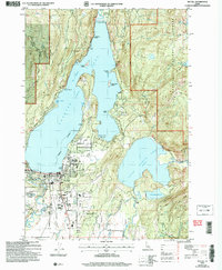
2004 Map of McCall
USGS Topo · Published 2007About this map
McCall serves as the focal point of this 2004 revision, situated at the southern tip of the expansive Payette Lake and the northern reaches of Long Valley. The town's infrastructure is clearly delineated, showing the McCall Airport, the Post Office, and educational facilities like the McCall Elem Sch. Waterfront development and recreation are central to the area's identity, with Ponderosa State Park occupying a significant peninsula that divides the main lake from the eastern reaches of Little Payette Lake.
Find a feature on this map
54 named features on this map. Tap any name to fly to it.
Don’t see what you’re looking for? This feature index may not catch every label — zoom into the map to look around manually.
Map Details
Editions of this 2004 McCall Map
This is the sole edition of this map. No revisions or reprints were ever made.
Other maps of this area

1911 · Meadows
USGS Topo · 1:125,000

1938 · Riggins
USGS Topo · 1:96,000

1945 · Riggins
USGS Topo · 1:125,000

1955 · Baker
USGS Topo · 1:250,000

1955 · Grangeville
USGS Topo · 1:250,000

1956 · Elk City
USGS Topo · 1:250,000

1957 · Challis
USGS Topo · 1:250,000

1959 · Baker
USGS Topo · 1:250,000

1959 · Grangeville
USGS Topo · 1:250,000

1960 · Elk City
USGS Topo · 1:250,000