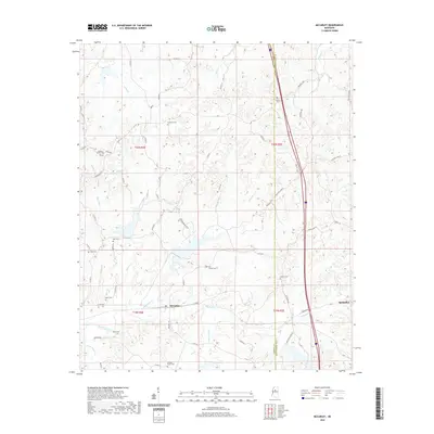
2020 Map of McCarley
USGS Topo · Published 2020About this map
The McCarley community sits at the heart of this landscape along the Carroll and Montgomery County line, situated between the upper reaches of Big Sand Creek and several rural tributaries. The topography is defined by a dense network of small waterways, including Loden Cr, Magic Cr, and Thompson Cr, which drain the wooded hills. For genealogists, the map is a significant resource for locating small family and community burial grounds scattered throughout the countryside, such as Pink Flower Cem, Hickory Grove Cem, and Pleasant Green Cem. The eastern portion of the area borders Winona, where the terrain begins to transition toward larger local settlements. Transportation routes like the Carrollton Road and McCarley Rd connect these outlying rural areas, while the presence of landmarks like Duck Hill Ranch reflects the agricultural character of the region in the early twenty-first century.
Find a feature on this map
64 named features on this map. Tap any name to fly to it.
Don’t see what you’re looking for? This feature index may not catch every label — zoom into the map to look around manually.
Map Details
Editions of this 2020 McCarley Map
This is the sole edition of this map. No revisions or reprints were ever made.
Other maps of this area

1953 · West Point
USGS Topo · 1:250,000

1954 · Duck Hill
USGS Topo · 1:62,500

1954 · McCarley
USGS Topo · 1:62,500

1958 · West Point
USGS Topo · 1:250,000

1963 · West Point
USGS Topo · 1:250,000

1966 · Winona
USGS Topo · 1:24,000

1968 · Winona
USGS Topo · 1:62,500
1975 · Bailey Lake
USGS Topo · 1:24,000
1975 · Coila
USGS Topo · 1:24,000
1978 · Coila
USGS Topo · 1:62,500