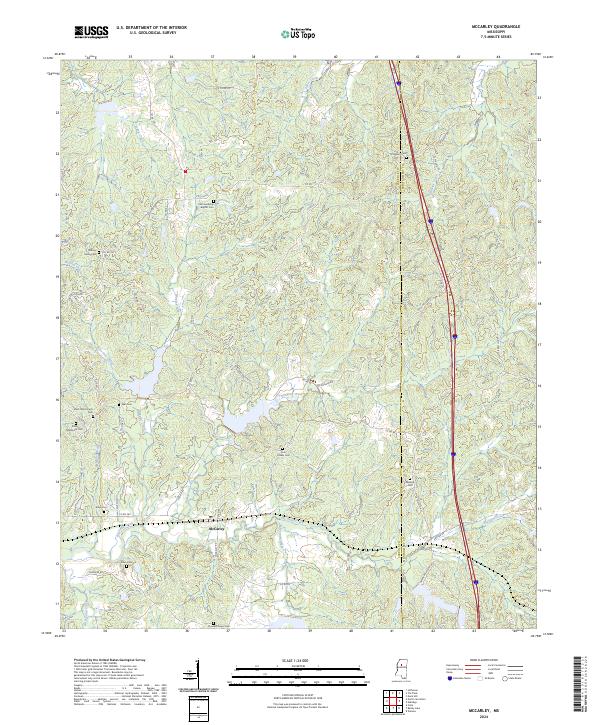
2024 Map of McCarley
USGS Topo · Published 2024About this map
McCarley serves as a central hub for this rural Mississippi landscape, where the boundary between Carroll and Montgomery counties divides the terrain. The area is defined by an intricate network of watercourses including Big Sand Creek, Thompson Creek, and Whitehead Creek, which carve through the wooded hills and valleys. This modern survey reflects a deeply rooted community structure, evidenced by numerous family and church-affiliated burial grounds such as Old Friendship Baptist Cem, Eden CME Church Cem, and the Pink Flower Cem. These sites, along with the Eden Methodist Cem, provide vital geographic markers for genealogists and local historians tracking early settlement patterns. A major interstate corridor cuts through the eastern portion of the quadrangle, contrasting the traditional rural road network like Carrollton Rd and McDonald Rd that connects the scattered homesteads and legacy landmarks.
Find a feature on this map
65 named features on this map. Tap any name to fly to it.
Don’t see what you’re looking for? This feature index may not catch every label — zoom into the map to look around manually.
Map Details
Editions of this 2024 McCarley Map
This is the sole edition of this map. No revisions or reprints were ever made.
Other maps of this area

1953 · West Point
USGS Topo · 1:250,000

1954 · Duck Hill
USGS Topo · 1:62,500

1954 · McCarley
USGS Topo · 1:62,500

1958 · West Point
USGS Topo · 1:250,000

1963 · West Point
USGS Topo · 1:250,000

1966 · Winona
USGS Topo · 1:24,000

1968 · Winona
USGS Topo · 1:62,500
1975 · Bailey Lake
USGS Topo · 1:24,000
1975 · Coila
USGS Topo · 1:24,000
1978 · Coila
USGS Topo · 1:62,500