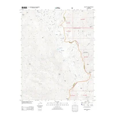
2013 Map of McCarty Park
USGS Topo · Published 2013About this map
Fir and the surrounding high-altitude terrain of the San Isabel National Forest dominate this 2013 survey of the Sangre de Cristo Mountains boundary. The map documents a complex landscape of drainage basins, including the headwaters of W Indian Cr and the N Fork Trinchera Cr, which cut through sharp ridges like Wagon Mesa. This area represents a transition from high-mountain peaks such as Napoleon Peak and Harrison Peak to the developed recreational and residential infrastructure near McCarty Park and Forbes Park Lake.
Find a feature on this map
67 named features on this map. Tap any name to fly to it.
Don’t see what you’re looking for? This feature index may not catch every label — zoom into the map to look around manually.
Map Details
Editions of this 2013 McCarty Park Map
This is the sole edition of this map. No revisions or reprints were ever made.
Other maps of this area

1889 · Huerfano Park
USGS Topo · 1:125,000

1892 · Huerfano Park
USGS Topo · 1:125,000

1954 · Trinidad
USGS Topo · 1:250,000

1955 · Trinidad
USGS Topo · 1:250,000

1958 · Trinidad
USGS Topo · 1:250,000

1959 · Trinidad
USGS Topo · 1:250,000

1963 · Mc Carty Park
USGS Topo · 1:24,000

1963 · La Veta Pass
USGS Topo · 1:24,000
1963 · La Veta
USGS Topo · 1:24,000
1963 · Cuchara
USGS Topo · 1:24,000