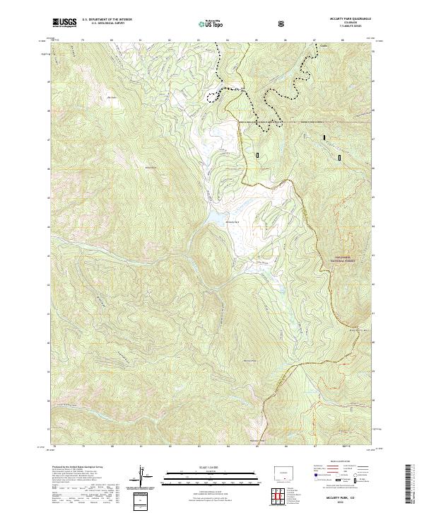
2022 Map of McCarty Park
USGS Topo · Published 2022About this map
The Sangre de Cristo Conservation Area and San Isabel National Forest dominate this high-altitude landscape along the border of Costilla and Huerfano counties. High peaks like Harrison Peak, Napoleon Peak, and Raspberry Mtn rise above a series of named parks and clearings, including McCarty Park, Elk Park, and Indian Park. This 2022 survey captures the complex modern road network winding through the wooded terrain, with hundreds of private drives like Forbes Park Rd, Wagon Mesa Loop, and Burgoyne Loop serving residential developments south of Codo.
Find a feature on this map
94 named features on this map. Tap any name to fly to it.
Don’t see what you’re looking for? This feature index may not catch every label — zoom into the map to look around manually.
Map Details
Editions of this 2022 McCarty Park Map
This is the sole edition of this map. No revisions or reprints were ever made.
Other maps of this area

1889 · Huerfano Park
USGS Topo · 1:125,000

1892 · Huerfano Park
USGS Topo · 1:125,000

1954 · Trinidad
USGS Topo · 1:250,000

1955 · Trinidad
USGS Topo · 1:250,000

1958 · Trinidad
USGS Topo · 1:250,000

1959 · Trinidad
USGS Topo · 1:250,000

1963 · Mc Carty Park
USGS Topo · 1:24,000

1963 · La Veta Pass
USGS Topo · 1:24,000
1963 · La Veta
USGS Topo · 1:24,000
1963 · Cuchara
USGS Topo · 1:24,000