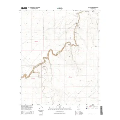
2014 Map of McCauley Sinks
USGS Topo · Published 2014About this map
McCauley Sinks and the meandering path of Chevelon Cr define this high-desert landscape in Navajo County. The terrain is deeply incised by a network of drainage systems, including Chevelon Canyon, Black Canyon, and Pony Canyon, which converge amidst the McCamant Hills. This 2014 survey illustrates the geographic intersection of high-plateau grazing lands and complex canyon topography, where features like Gods Pocket and Burro Basin provided natural enclosures and landmarks for local ranching operations. The area is accessed by a distinctive grid of rural routes with equine-inspired names such as Lightening Rd, Stallion Rd, and Colt Rd. The map also highlights vital water resources in this arid environment, such as Babbitt Tank, which were essential for the survival of livestock and local wildlife before modern development reached this section of the Arizona backcountry.
Find a feature on this map
30 named features on this map. Tap any name to fly to it.
Don’t see what you’re looking for? This feature index may not catch every label — zoom into the map to look around manually.
Map Details
Editions of this 2014 McCauley Sinks Map
This is the sole edition of this map. No revisions or reprints were ever made.
Other maps of this area

1886 · Holbrook
USGS Topo · 1:250,000

1893 · Holbrook
USGS Topo · 1:250,000

1954 · Holbrook
USGS Topo · 1:250,000
1955 · St. Joseph 2 NW
USGS Topo · 1:24,000

1955 · Joseph City
USGS Topo · 1:62,500

1957 · Holbrook
USGS Topo · 1:250,000

1958 · Holbrook
USGS Topo · 1:250,000

1960 · Holbrook
USGS Topo · 1:250,000
1970 · Hibbard
USGS Topo · 1:24,000
1970 · Relic Point
USGS Topo · 1:24,000