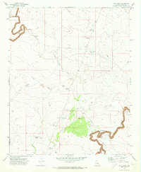
1970 Map of Relic Point
USGS Topo · Published 1973About this map
The high plateau of Navajo County in 1970 is defined by the deep incisions of Chevelon Canyon and Clear Creek, where water management and ranching infrastructure dominate the arid landscape. The area is marked by an extensive network of stock tanks and reservoirs, including Sixteenmile Tank, Big Tanks, and White Tank, which supported the local cattle industry. An Aqueduct and Pumping Station near the canyon floor suggest the technical efforts required to move water through this high-altitude desert environment.
Find a feature on this map
26 named features on this map. Tap any name to fly to it.
Don’t see what you’re looking for? This feature index may not catch every label — zoom into the map to look around manually.
Map Details
Editions of this 1970 Relic Point Map
2 editions found
Other maps of this area

1886 · Holbrook
USGS Topo · 1:250,000

1893 · Holbrook
USGS Topo · 1:250,000

1954 · Holbrook
USGS Topo · 1:250,000

1955 · Sunset Knoll 2 SE
USGS Topo · 1:24,000

1955 · Sunset Pass
USGS Topo · 1:62,500

1957 · Holbrook
USGS Topo · 1:250,000

1958 · Holbrook
USGS Topo · 1:250,000

1960 · Holbrook
USGS Topo · 1:250,000
1970 · Hibbard
USGS Topo · 1:24,000
1970 · Chevelon Butte
USGS Topo · 1:24,000