
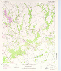
1957 Map of McClanahan
USGS Topo · Published 1958About this map
Mc Clanahan sits at a crossroads in the north-central portion of this mid-century survey, surrounded by the headwaters of numerous creeks that define the local drainage. The landscape is marked by the presence of both the Missouri Pacific and the Texas and New Orleans (SP) railroads, which parallel the major watercourses and connect the rural communities. Infrastructure for nearby Marlin is evident in the twin reservoirs of Marlin City Lake and New City Lake, supported by a dedicated Filtration Plant and the National Guard Armory. Genealogists and local historians can locate several rural landmarks, including the Marvin Allen Ch, Springhill Ch, and Taylor Chapel Cem. The terrain rises toward Bald Hill in the south, while the northeast is characterized by the winding path of Brushy Creek and Pin Oak Creek.
Find a feature on this map
29 named features on this map. Tap any name to fly to it.
Don’t see what you’re looking for? This feature index may not catch every label — zoom into the map to look around manually.
Map Details
Editions of this 1957 McClanahan Map
2 editions found
Other maps of this area

1954 · Waco
USGS Topo · 1:250,000

1955 · Waco
USGS Topo · 1:250,000

1957 · Otto
USGS Topo · 1:24,000

1957 · Riesel
USGS Topo · 1:24,000

1957 · Marlin
USGS Topo · 1:24,000

1962 · Reagan
USGS Topo · 1:24,000

1962 · Cedar Springs
USGS Topo · 1:24,000

1962 · Bremond
USGS Topo · 1:24,000

1965 · Kosse West
USGS Topo · 1:24,000
1966 · Odds
USGS Topo · 1:24,000