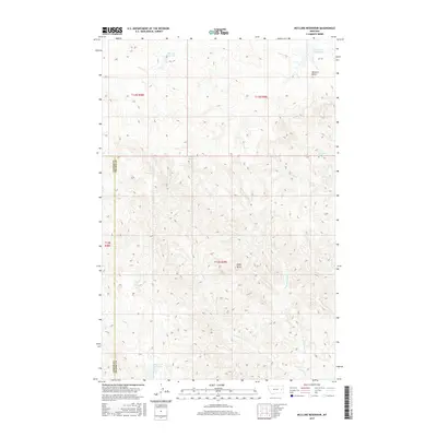
2017 Map of McClure Reservoir
USGS Topo · Published 2017About this map
McClure Reservoir and Silvertip Reservoir anchor this landscape along the border of Custer and Prairie Counties. The terrain is defined by a dense network of intermittent drainages, including the N Fork Crooked Cr and Lost Boy Cr, which reveal the complex erosion patterns of the eastern Montana plains. Named landmarks such as McClure Butte and Eagle Butte rise above the surrounding drainages, serving as essential points of orientation in a region largely devoid of major infrastructure. The distribution of small water sources like Bootlegger Spring and Johnson Spring, alongside the Hunter Cr Reservoir, underscores the critical importance of water management in this cattle-ranching and grazing country. This survey illustrates how the land is organized into the Public Land Survey System, with township and range lines like T13N R49E guiding the division of these wide-open spaces.
Find a feature on this map
17 named features on this map. Tap any name to fly to it.
Don’t see what you’re looking for? This feature index may not catch every label — zoom into the map to look around manually.
Map Details
Editions of this 2017 McClure Reservoir Map
This is the sole edition of this map. No revisions or reprints were ever made.
Other maps of this area

1953 · Miles City
USGS Topo · 1:250,000

1957 · Miles City
USGS Topo · 1:250,000

1958 · Miles City
USGS Topo · 1:250,000

1969 · Zero
USGS Topo · 1:24,000

1969 · Kinsey NE
USGS Topo · 1:24,000
1969 · Kinsey NW
USGS Topo · 1:24,000

1972 · Calypso
USGS Topo · 1:24,000

1972 · Papps Reservoir
USGS Topo · 1:24,000

1972 · Mc Clure Reservoir
USGS Topo · 1:24,000

1972 · Mc Cloud
USGS Topo · 1:24,000