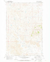
1969 Map of Kinsey NW
USGS Topo · Published 1973About this map
Harris Creek and several other drainage systems dominate this 1968 topographic survey of the plains in Custer County, Montana. The landscape is defined by the erosive patterns of Caprock Coulee and the winding paths of Custer Creek and Cabin Creek. This specific quadrangle, mapped by photogrammetric methods just before the 1970s, illustrates the complex network of intermittent water sources and high-ground ridges characteristic of the Yellowstone River watershed. Local landmarks like Snaggs Creek and a prominent Spring indicate the essential water locations that historically dictated movement and land use in this open ranching country. The intricate contour lines reveal the subtle but significant elevation changes between the creek beds and the dividing caprock plateaus.
Find a feature on this map
6 named features on this map. Tap any name to fly to it.
Don’t see what you’re looking for? This feature index may not catch every label — zoom into the map to look around manually.
Map Details
Editions of this 1969 Kinsey NW Map
This is the sole edition of this map. No revisions or reprints were ever made.
Other maps of this area

1953 · Miles City
USGS Topo · 1:250,000

1957 · Miles City
USGS Topo · 1:250,000

1958 · Miles City
USGS Topo · 1:250,000

1965 · Morehouse Creek
USGS Topo · 1:24,000

1969 · Noble Reservoir
USGS Topo · 1:24,000

1969 · Kinsey NE
USGS Topo · 1:24,000
1969 · Coal Bank Spring
USGS Topo · 1:24,000

1969 · Kinsey
USGS Topo · 1:24,000
1969 · Shirley
USGS Topo · 1:24,000

1972 · Mc Clure Reservoir
USGS Topo · 1:24,000