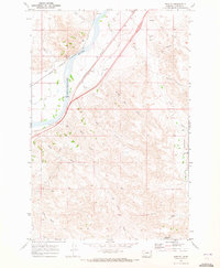
1969 Map of Shirley
USGS Topo · Published 1973About this map
The Yellowstone River carves through this Custer County landscape, serving as a corridor for the dual rail lines of the Milwaukee Chicago St Paul and Pacific and the Burlington Northern. The settlement of Shirley sits at the junction of these transit routes, while Bonfield marks a point further north along the riverbanks. The infrastructure here is defined by early-century industrial and agricultural development, including a Pumping Sta and the Main Canal which draws water toward the Kinsey area. To the east and south, the terrain transitions into a dense network of coulees and drainages such as Dead Horse Creek, Deep Creek, and North Dixon Creek. This map reveals the intricate water management of the High Plains, from the McFarland Reservoir in the south to various springs and a Landing Strip that supported the remote ranching operations of the late 1960s.
Find a feature on this map
26 named features on this map. Tap any name to fly to it.
Don’t see what you’re looking for? This feature index may not catch every label — zoom into the map to look around manually.
Map Details
Editions of this 1969 Shirley Map
This is the sole edition of this map. No revisions or reprints were ever made.
Other maps of this area

1953 · Miles City
USGS Topo · 1:250,000

1957 · Miles City
USGS Topo · 1:250,000

1958 · Miles City
USGS Topo · 1:250,000

1969 · Corral Butte
USGS Topo · 1:24,000

1969 · Zero
USGS Topo · 1:24,000

1969 · Kinsey NE
USGS Topo · 1:24,000

1969 · Kinsey
USGS Topo · 1:24,000

1969 · Government Hill
USGS Topo · 1:24,000

1969 · The Knob
USGS Topo · 1:24,000

1969 · Buck Mountain
USGS Topo · 1:24,000