
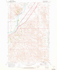
1969 Map of Corral Butte
USGS Topo · Published 1972About this map
Corral Butte and the surrounding high country define this section of the Montana plains during the late 1960s. Straddling the boundary of Custer County and Prairie County, the landscape is carved by an intricate network of drainages including Williams Creek, Prairie Creek, and Maggie Creek. The map documents a sparsely settled ranching or resource extraction environment, evidenced by the presence of a Pipeline and scattered Jeep Trail routes that navigate the complex topography.
Find a feature on this map
20 named features on this map. Tap any name to fly to it.
Don’t see what you’re looking for? This feature index may not catch every label — zoom into the map to look around manually.
Map Details
Editions of this 1969 Corral Butte Map
This is the sole edition of this map. No revisions or reprints were ever made.
Other maps of this area

1953 · Miles City
USGS Topo · 1:250,000

1957 · Miles City
USGS Topo · 1:250,000

1958 · Miles City
USGS Topo · 1:250,000

1969 · Spring Draw
USGS Topo · 1:24,000

1969 · Zero NE
USGS Topo · 1:24,000

1969 · Zero
USGS Topo · 1:24,000

1969 · Kinsey NE
USGS Topo · 1:24,000

1969 · The Knob
USGS Topo · 1:24,000

1969 · Buck Mountain
USGS Topo · 1:24,000
1969 · Shirley
USGS Topo · 1:24,000