
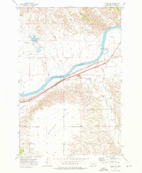
1969 Map of Zero NE
USGS Topo · Published 1973About this map
The Powder River meanders through this portion of Prairie County, marking a landscape defined by dramatic drainage patterns and deep coulees. This 1969 field-checked survey reveals the intricate topography of the Montana plains, where narrow waterways like Conns Creek and Tenmile Creek cut through the high ground. The map captures the area during a period of resource exploration and utility expansion, noted by scattered infrastructure such as a Drill Hole and a prominent Radio Tower. The lack of dense settlement emphasizes the expansive, rural character of the region, where land use is dictated by the rugged breaks and flat-topped buttes typical of the lower Powder River basin. These features provide a clear look at the hydraulic and geological formations that have historically influenced grazing and transit in this part of the state.
Find a feature on this map
10 named features on this map. Tap any name to fly to it.
Don’t see what you’re looking for? This feature index may not catch every label — zoom into the map to look around manually.
Map Details
Editions of this 1969 Zero NE Map
This is the sole edition of this map. No revisions or reprints were ever made.
Other maps of this area

1953 · Miles City
USGS Topo · 1:250,000

1957 · Miles City
USGS Topo · 1:250,000

1958 · Miles City
USGS Topo · 1:250,000

1969 · Corral Butte
USGS Topo · 1:24,000

1969 · Spring Draw
USGS Topo · 1:24,000

1969 · Zero
USGS Topo · 1:24,000

1969 · Flat Top Butte SW
USGS Topo · 1:24,000

1969 · Flat Top Butte
USGS Topo · 1:24,000

1972 · Calypso
USGS Topo · 1:24,000
1972 · Fallon SW
USGS Topo · 1:24,000