
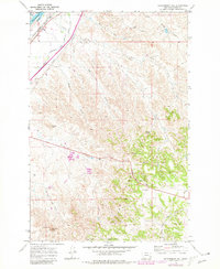
1969 Map of Government Hill
USGS Topo · Published 1973About this map
The Yellowstone River cuts through the northwest corner of this 1969 survey, where the small settlement of Tusler sits at a critical junction of northern Montana transport. Parallel rail lines of the Chicago Milwaukee St Paul and Pacific and Burlington Northern track the river's path, reflecting the heavy-duty infrastructure required to move resources through Custer County. Further south, the Tongue River Pipeline snakes across a landscape defined by the prominent Government Hills and distinctive landmarks like Strawberry Hill. The transition from the irrigated lowlands near the Jones District Canal to the higher, broken terrain around Badland Butte and Angelwing Butte highlights the contrast between the fertile river valley and the arid Montana uplands. This map documents a working landscape where water management and industrial transit meet isolated springs such as Drownin Spring.
Find a feature on this map
33 named features on this map. Tap any name to fly to it.
Don’t see what you’re looking for? This feature index may not catch every label — zoom into the map to look around manually.
Map Details
Editions of this 1969 Government Hill Map
2 editions found
Other maps of this area

1953 · Miles City
USGS Topo · 1:250,000

1957 · Miles City
USGS Topo · 1:250,000

1958 · Miles City
USGS Topo · 1:250,000

1968 · Miles City
USGS Topo · 1:24,000

1968 · Paddy Fay Creek
USGS Topo · 1:24,000

1969 · Haines Springs
USGS Topo · 1:24,000

1969 · Noble Reservoir
USGS Topo · 1:24,000

1969 · Kinsey
USGS Topo · 1:24,000

1969 · The Knob
USGS Topo · 1:24,000
1969 · Whitney Creek
USGS Topo · 1:24,000