
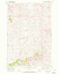
1968 Map of Paddy Fay Creek
USGS Topo · Published 1972About this map
The Tongue River meanders through the heart of Custer County, shaping a landscape defined by sharp transitions between high bluffs and fertile bottomlands. In the late 1960s, the Tongue and Yellowstone River Irrigation District Canal followed the eastern bench of the river valley, a critical artery for agriculture in this semi-arid region. To the south, the Old Fort Keogh Military Reservation Boundary marks the historic reach of one of Montana's most significant frontier military posts. The terrain is deeply dissected by numerous watercourses, including Paddy Fay Creek, Cowles Creek, and Squaw Creek, which drain the surrounding uplands toward the river. Scattered evidence of land use is visible through a Gaging Sta along the river and a Drill Hole in the western hills, reflecting the region's focus on water management and resource exploration.
Find a feature on this map
12 named features on this map. Tap any name to fly to it.
Don’t see what you’re looking for? This feature index may not catch every label — zoom into the map to look around manually.
Map Details
Editions of this 1968 Paddy Fay Creek Map
This is the sole edition of this map. No revisions or reprints were ever made.
Other maps of this area

1953 · Miles City
USGS Topo · 1:250,000

1957 · Miles City
USGS Topo · 1:250,000

1958 · Miles City
USGS Topo · 1:250,000

1968 · Big Hill
USGS Topo · 1:24,000

1968 · Miles City
USGS Topo · 1:24,000

1968 · Lignite Creek
USGS Topo · 1:24,000
1969 · Jack Creek NW
USGS Topo · 1:24,000

1969 · Horse Creek
USGS Topo · 1:24,000

1969 · Circle L Creek
USGS Topo · 1:24,000

1969 · Government Hill
USGS Topo · 1:24,000