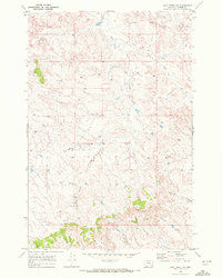
1969 Map of Jack Creek NW
USGS Topo · Published 1972About this map
The rolling drainage basins of Custer County are defined here by an intricate network of seasonal waterways feeding into Moon Creek. This 1960s landscape is largely shaped by cattle ranching and land management, evidenced by the numerous red dashed lines indicating selected fence lines that divide the township and range sections. The terrain is characterized by dissected plateaus where Thorpe Creek and Kennedy Creek have carved out a series of ridges and draws.
Find a feature on this map
10 named features on this map. Tap any name to fly to it.
Don’t see what you’re looking for? This feature index may not catch every label — zoom into the map to look around manually.
Map Details
Editions of this 1969 Jack Creek NW Map
This is the sole edition of this map. No revisions or reprints were ever made.
Other maps of this area

1953 · Miles City
USGS Topo · 1:250,000

1954 · Forsyth
USGS Topo · 1:250,000

1957 · Miles City
USGS Topo · 1:250,000

1957 · Forsyth
USGS Topo · 1:250,000

1958 · Miles City
USGS Topo · 1:250,000

1958 · Forsyth
USGS Topo · 1:250,000

1968 · Lignite Creek
USGS Topo · 1:24,000

1968 · Paddy Fay Creek
USGS Topo · 1:24,000

1968 · Horton
USGS Topo · 1:24,000
1969 · Moon Creek School
USGS Topo · 1:24,000