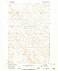
1969 Map of Coal Bank Spring
USGS Topo · Published 1973About this map
Coal Bank Spring and the surrounding drainage basins of Custer County dominate this 1969 landscape, providing a detailed look at the seasonal water sources vital to life in eastern Montana. The map illustrates a network of ephemeral watercourses, including Harris Creek and Muster Creek, which carve through the terrain and define the local topography. This document serves as a critical record of land use before modern developments, showing the established routes like Caprock Road and the significant geographic breaks of Caprock Coulee. Smaller features such as a centrally located Spring and the West Fork Sand Creek in the southwest quadrant reveal the intricate natural plumbing of this semi-arid region during the late 1960s. For researchers, the map provides precise locations for these water points and the primitive road network that connected the disparate parts of this ranching country.
Find a feature on this map
8 named features on this map. Tap any name to fly to it.
Don’t see what you’re looking for? This feature index may not catch every label — zoom into the map to look around manually.
Map Details
Editions of this 1969 Coal Bank Spring Map
This is the sole edition of this map. No revisions or reprints were ever made.
Other maps of this area

1953 · Miles City
USGS Topo · 1:250,000

1957 · Miles City
USGS Topo · 1:250,000

1958 · Miles City
USGS Topo · 1:250,000

1965 · Twin Buttes School
USGS Topo · 1:24,000

1965 · Morehouse Creek
USGS Topo · 1:24,000

1969 · Horse Creek Hill
USGS Topo · 1:24,000

1969 · Noble Reservoir
USGS Topo · 1:24,000
1969 · Deadman Creek
USGS Topo · 1:24,000

1969 · Kinsey
USGS Topo · 1:24,000
1969 · Kinsey NW
USGS Topo · 1:24,000