
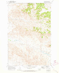
1969 Map of Hogan Creek
USGS Topo · Published 1973About this map
Bradshaw Ranch anchors this portion of eastern Montana, where the ranching economy is clearly etched into the drainage patterns of the Custer County landscape. The map highlights a series of small-scale water management features vital for livestock in a semi-arid environment, including Perkins Dam, Crowbar Dam, and the evocatively named Dead Cow Reservoir. These artificial catchments sit alongside a complex network of seasonal waterways such as Johannes Gulch, Norton Creek, and Locate Creek. The presence of Flowing Wells in the southern reaches further illustrates the ongoing efforts to secure reliable water sources for grazing land. This 1969 field-checked survey preserves the layout of these family-named landmarks and range improvements just as the modern agricultural infrastructure was taking its current form.
Find a feature on this map
17 named features on this map. Tap any name to fly to it.
Don’t see what you’re looking for? This feature index may not catch every label — zoom into the map to look around manually.
Map Details
Editions of this 1969 Hogan Creek Map
This is the sole edition of this map. No revisions or reprints were ever made.
Other maps of this area

1953 · Miles City
USGS Topo · 1:250,000

1957 · Miles City
USGS Topo · 1:250,000

1958 · Miles City
USGS Topo · 1:250,000

1969 · Little Whitney Creek
USGS Topo · 1:24,000

1969 · Spring Draw
USGS Topo · 1:24,000

1969 · Knowlton
USGS Topo · 1:24,000

1969 · Locate SE
USGS Topo · 1:24,000

1969 · Montague Butte
USGS Topo · 1:24,000

1969 · Flat Top Butte SW
USGS Topo · 1:24,000
1969 · Red Knob
USGS Topo · 1:24,000