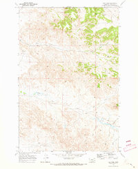
1969 Map of Red Knob
USGS Topo · Published 1973About this map
Red Knob dominates the eastern topography of this Custer County landscape, presiding over a complex network of seasonal drainages and grazing land. The drainage patterns of the late 1960s define the territory, with the North Fork Horse Creek and main Horse Creek winding through the northern sections while Sheep Creek and its southern tributaries like Alice Creek and Bert Creek carve the southern reaches. This is a region defined by water access and ranching infrastructure, where intermittent flows are supplemented by several Flowing Wells scattered across the township lines.
Find a feature on this map
16 named features on this map. Tap any name to fly to it.
Don’t see what you’re looking for? This feature index may not catch every label — zoom into the map to look around manually.
Map Details
Editions of this 1969 Red Knob Map
This is the sole edition of this map. No revisions or reprints were ever made.
Other maps of this area

1953 · Miles City
USGS Topo · 1:250,000

1957 · Miles City
USGS Topo · 1:250,000

1958 · Miles City
USGS Topo · 1:250,000

1969 · Mizpah
USGS Topo · 1:24,000

1969 · Knowlton
USGS Topo · 1:24,000

1969 · Hogan Creek
USGS Topo · 1:24,000

1969 · Tepee Butte NE
USGS Topo · 1:24,000

1969 · Locate SE
USGS Topo · 1:24,000

1969 · Montague Butte
USGS Topo · 1:24,000
1969 · Pennock Creek
USGS Topo · 1:24,000