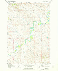
1969 Map of Garland School
USGS Topo · Published 1973About this map
The Tongue River meanders through a landscape defined by sharp coulees and deep drainage systems in this late 1960s survey of Custer County. The settlement of Garland serves as the focal point, situated near the Garland Sch and the intersection of local transport routes. The river's broad floodplain is flanked by a complex network of seasonal waterways, including Yank Creek, Foster Creek, and Haddow Creek, which cut through the surrounding uplands.
Find a feature on this map
19 named features on this map. Tap any name to fly to it.
Don’t see what you’re looking for? This feature index may not catch every label — zoom into the map to look around manually.
Map Details
Editions of this 1969 Garland School Map
This is the sole edition of this map. No revisions or reprints were ever made.
Other maps of this area

1953 · Miles City
USGS Topo · 1:250,000

1954 · Hardin
USGS Topo · 1:250,000

1954 · Ekalaka
USGS Topo · 1:250,000

1954 · Forsyth
USGS Topo · 1:250,000

1956 · Ekalaka
USGS Topo · 1:250,000

1957 · Miles City
USGS Topo · 1:250,000

1957 · Hardin
USGS Topo · 1:250,000

1957 · Forsyth
USGS Topo · 1:250,000

1958 · Miles City
USGS Topo · 1:250,000

1958 · Ekalaka
USGS Topo · 1:250,000