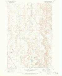
1969 Map of Deadman Creek
USGS Topo · Published 1973About this map
Deadman Creek winds through this sparsely settled landscape in eastern Montana, carving through the high plains of Custer County during the late 1960s. The map captures a working ranching and resource-exploration landscape, characterized by drainage systems like Crooked Creek and Owens Coulee. Human infrastructure is minimal and functional, represented by a singular Corral and a network of unimproved paths including a noted Jeep Trail. Evidence of subsurface activity appears through labels for a Well and a Drill Hole, suggesting the early stages of energy or water development in this arid terrain. Near the confluence of North Sunday Creek, the elevation point BR 2546 marks a rare specific surveyed landmark in a territory defined primarily by its complex natural topography.
Find a feature on this map
9 named features on this map. Tap any name to fly to it.
Don’t see what you’re looking for? This feature index may not catch every label — zoom into the map to look around manually.
Map Details
Editions of this 1969 Deadman Creek Map
This is the sole edition of this map. No revisions or reprints were ever made.
Other maps of this area

1953 · Miles City
USGS Topo · 1:250,000

1954 · Forsyth
USGS Topo · 1:250,000

1957 · Miles City
USGS Topo · 1:250,000

1957 · Forsyth
USGS Topo · 1:250,000

1958 · Miles City
USGS Topo · 1:250,000

1958 · Forsyth
USGS Topo · 1:250,000

1968 · Big Hill
USGS Topo · 1:24,000

1968 · Miles City
USGS Topo · 1:24,000

1968 · Butterfly Creek
USGS Topo · 1:24,000

1969 · Horse Creek Hill
USGS Topo · 1:24,000