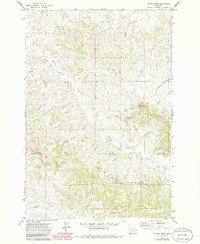
1971 Map of Hayes Point
USGS Topo · Published 1986About this map
The rolling drainage basins of Custer National Forest define this landscape along the border of Custer and Powder River Counties. Centered on the prominence of Hayes Point, the terrain is marked by a complex network of seasonal drainages including Swain Coulee, Mullins Coulee, and Liscom Creek. The area’s character is primarily defined by the intersection of forest management and early energy exploration, evidenced by scattered infrastructure like the Gas Well and Drill Hole in the northwestern hills. Transport through these remote reaches relies on Liscom Road and various rugged tracks, including a Jeep Trail that navigates the southern forest boundary. Ranching and land management legacy is visible through identified water sources such as Liscom Well and Coyote Well, which provided vital support in a landscape defined by The Breaks.
Find a feature on this map
22 named features on this map. Tap any name to fly to it.
Don’t see what you’re looking for? This feature index may not catch every label — zoom into the map to look around manually.
Map Details
Editions of this 1971 Hayes Point Map
2 editions found
Other maps of this area

1954 · Hardin
USGS Topo · 1:250,000

1954 · Ekalaka
USGS Topo · 1:250,000

1956 · Ekalaka
USGS Topo · 1:250,000

1957 · Hardin
USGS Topo · 1:250,000

1958 · Ekalaka
USGS Topo · 1:250,000

1958 · Hardin
USGS Topo · 1:250,000

1965 · Ekalaka
USGS Topo · 1:250,000

1966 · Stacey
USGS Topo · 1:24,000

1966 · Beaver Creek School
USGS Topo · 1:24,000

1966 · Cook Creek Reservoir
USGS Topo · 1:24,000