
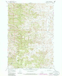
1966 Map of Stacey
USGS Topo · Published 1969About this map
Custer National Forest dominates this mid-1960s terrain, where the high-plains landscape is defined by a dense network of seasonal draws and springs essential for livestock and forestry. The small community of Stacey sits along the eastern edge of the quadrangle near Little Pumpkin Creek, serving as a focal point for local families whose children attended the nearby South Stacey Sch. Evidence of federal land management and recreational use is clear, with the Whitetail Ranger Sta, the Holiday Campground, and the Liscom Lookout atop Liscom Butte all situated to monitor and maintain these wooded ridges. The presence of a single Oil Well in the southwest suggests early industrial exploration, while numerous named water sources like Split Rock Spring and Bottom Crib Spring reflect the vital importance of water rights in this part of Montana.
Find a feature on this map
50 named features on this map. Tap any name to fly to it.
Don’t see what you’re looking for? This feature index may not catch every label — zoom into the map to look around manually.
Map Details
Editions of this 1966 Stacey Map
2 editions found
Other maps of this area

1954 · Hardin
USGS Topo · 1:250,000

1954 · Ekalaka
USGS Topo · 1:250,000

1956 · Ekalaka
USGS Topo · 1:250,000

1957 · Hardin
USGS Topo · 1:250,000

1958 · Ekalaka
USGS Topo · 1:250,000

1958 · Hardin
USGS Topo · 1:250,000

1965 · Ekalaka
USGS Topo · 1:250,000

1966 · Coleman Draw
USGS Topo · 1:24,000

1966 · Home Creek Butte
USGS Topo · 1:24,000

1966 · Beaver Creek School
USGS Topo · 1:24,000