
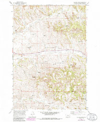
1966 Map of Coleman Draw
USGS Topo · Published 1969About this map
Custer National Forest anchors this mid-century look at the Montana rangeland, where water management defines the human footprint on the landscape. The intricate network of draws and creeks, including Otter Creek and Threemile Creek, is punctuated by dozens of man-made features essential for livestock and local industry. These include named improvements like the Gaskill Reservoir and Necessity Reservoir, alongside numerous family-named landmarks such as the Thomas Draw Well and McLatchy Well.
Find a feature on this map
44 named features on this map. Tap any name to fly to it.
Don’t see what you’re looking for? This feature index may not catch every label — zoom into the map to look around manually.
Map Details
Editions of this 1966 Coleman Draw Map
2 editions found
Other maps of this area

1954 · Hardin
USGS Topo · 1:250,000

1954 · Ekalaka
USGS Topo · 1:250,000

1956 · Ekalaka
USGS Topo · 1:250,000

1957 · Hardin
USGS Topo · 1:250,000

1958 · Ekalaka
USGS Topo · 1:250,000

1958 · Hardin
USGS Topo · 1:250,000

1965 · Ekalaka
USGS Topo · 1:250,000

1966 · Stacey
USGS Topo · 1:24,000

1966 · Home Creek Butte
USGS Topo · 1:24,000

1966 · Beaver Creek School
USGS Topo · 1:24,000