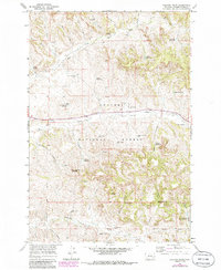
1966 Map of Coleman Draw
USGS Topo · Published 1986About this map
Custer National Forest encompasses much of this landscape in southern Montana, where the topography is defined by the headwaters of several drainages and a network of named springs and wells. The map reveals an area where water management was critical for ranching and resource extraction in the mid-1960s, evidenced by the numerous reservoirs such as Necessity Reservoir, Gaskill Reservoir, and Hanic Reservoir. The rural infrastructure of the era is anchored by the Home Creek Sch and a series of deep-reaching landmarks like the Coal Mine Project Well and Bryan Mine, suggesting a legacy of both grazing and subsurface exploration. Transport is dominated by the route of Highway 212 crossing Home Creek, while numerous named draws like Thomas Draw and Shorty Draw carve the terrain between Red Top Hill and the North Fork Stafford Creek.
Find a feature on this map
41 named features on this map. Tap any name to fly to it.
Don’t see what you’re looking for? This feature index may not catch every label — zoom into the map to look around manually.
Map Details
Editions of this 1966 Coleman Draw Map
2 editions found
Other maps of this area

1954 · Hardin
USGS Topo · 1:250,000

1954 · Ekalaka
USGS Topo · 1:250,000

1956 · Ekalaka
USGS Topo · 1:250,000

1957 · Hardin
USGS Topo · 1:250,000

1958 · Ekalaka
USGS Topo · 1:250,000

1958 · Hardin
USGS Topo · 1:250,000

1965 · Ekalaka
USGS Topo · 1:250,000

1966 · Coleman Draw
USGS Topo · 1:24,000

1966 · Stacey
USGS Topo · 1:24,000

1966 · Home Creek Butte
USGS Topo · 1:24,000