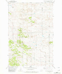
1981 Map of Foundation Spring
USGS Topo · Published 1981About this map
Foundation Spring serves as a vital water source in this corner of the High Plains, where the landscape is defined by a network of seasonal drainages and draws. Flowing through the southeastern portion of the quadrangle, Miles City Creek and Hay Creek carve through the terrain, while Locate Creek and its North Fork Locate Creek dominate the northern section. This 1981 edition, based on mid-1970s aerial photography, captures the sparse, utilitarian nature of the rural environment spanning the Custer and Fallon County line. The presence of a Gravel Pit and several strategically placed Tanks for livestock water suggest a landscape primarily dedicated to ranching and local resource extraction. Extensive fence lines, indicated by fine red dashed markings, delineate the division of these wide-open rangelands near Foundation Draw.
Find a feature on this map
12 named features on this map. Tap any name to fly to it.
Don’t see what you’re looking for? This feature index may not catch every label — zoom into the map to look around manually.
Map Details
Editions of this 1981 Foundation Spring Map
This is the sole edition of this map. No revisions or reprints were ever made.
Other maps of this area

1953 · Miles City
USGS Topo · 1:250,000

1957 · Miles City
USGS Topo · 1:250,000

1958 · Miles City
USGS Topo · 1:250,000

1969 · Knowlton
USGS Topo · 1:24,000

1969 · Tepee Butte NE
USGS Topo · 1:24,000

1969 · Montague Butte
USGS Topo · 1:24,000
1980 · Miles City
USGS Topo · 1:100,000

1981 · Baker
USGS Topo · 1:100,000
1981 · Bracket Butte
USGS Topo · 1:24,000

1981 · Nelson Butte
USGS Topo · 1:24,000