1981 Map of Baker
USGS Topo · Published 1981About this map
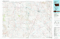
Baker stands at the center of this 1981 landscape, where the Chicago Milwaukee St Paul and Pacific railroad cuts a diagonal line across the high plains. The map illustrates a region defined by its wide creek drainage systems, notably O'Fallon Creek and Pennel Creek, which weave through a terrain marked by distinctive geological formations like Seven-up Butte and Bracket Butte.
Find a feature on this map
66 named features on this map. Tap any name to fly to it.
Don’t see what you’re looking for? This feature index may not catch every label — zoom into the map to look around manually.
Map Details
Editions of this 1981 Baker Map
This is the sole edition of this map. No revisions or reprints were ever made.
Other maps of this area

1935 · Buffalo
USGS Topo · 1:125,000

1953 · Miles City
USGS Topo · 1:250,000

1953 · Dickinson
USGS Topo · 1:250,000

1954 · Lemmon
USGS Topo · 1:250,000

1954 · Ekalaka
USGS Topo · 1:250,000

1956 · Ekalaka
USGS Topo · 1:250,000

1957 · Dickinson
USGS Topo · 1:250,000

1957 · Lemmon
USGS Topo · 1:250,000

1957 · Miles City
USGS Topo · 1:250,000

1958 · Miles City
USGS Topo · 1:250,000