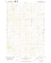
1979 Map of Mills Creek West
USGS Topo · Published 1979About this map
Monarch Creek and a network of numbered and named tributaries define this Custer County landscape as it appeared in the late 1970s. The terrain is characterized by intricate drainage systems feeding into Mills Creek, including First Creek, Second Creek, and Third Creek. This systematic naming convention, alongside features like May Creek and Elmhurst Creek, illustrates the essential relationship between water sources and land management in this part of Montana. Human modification of the arid environment is evident through the presence of Jones Reservoir and Love Reservoir. The survey also captures evidence of industrial exploration or geological testing, with several Drill Hole locations marked across the quadrangle, particularly near the headwaters of Third Creek and along the eastern boundary. The absence of major settlements highlights the remote, ranching-oriented character of the region during this era.
Find a feature on this map
12 named features on this map. Tap any name to fly to it.
Don’t see what you’re looking for? This feature index may not catch every label — zoom into the map to look around manually.
Map Details
Editions of this 1979 Mills Creek West Map
This is the sole edition of this map. No revisions or reprints were ever made.
Other maps of this area

1953 · Miles City
USGS Topo · 1:250,000

1954 · Ekalaka
USGS Topo · 1:250,000

1956 · Ekalaka
USGS Topo · 1:250,000

1957 · Miles City
USGS Topo · 1:250,000

1958 · Miles City
USGS Topo · 1:250,000

1958 · Ekalaka
USGS Topo · 1:250,000

1965 · Ekalaka
USGS Topo · 1:250,000

1969 · Forty Creek
USGS Topo · 1:24,000

1969 · Tepee Butte
USGS Topo · 1:24,000
1969 · Bear Jaw Creek
USGS Topo · 1:24,000