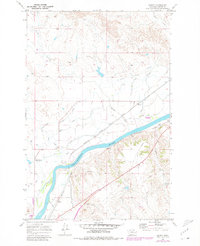
1969 Map of Kinsey
USGS Topo · Published 1980About this map
The Yellowstone River anchors this corner of Custer County, serving as the vital artery for an intricate system of agricultural development and transportation. In the late 1960s, the landscape around the settlement of Kinsey was defined by a complex irrigation network, including the Kinsey Highline Canal, Kinsey Middle Canal, and Kinsey Lower Canal. These waterways, managed in part via the Kinsey No 2 Pumping Sta, transformed the arid terrain adjacent to Muster Creek into productive land. Parallel rail lines of the Chicago Milwaukee St Paul and Pacific and the Burlington Northern trace the river's southern bank through Tusler, highlighting the area's role as a transit corridor for Montana's eastern plains. The map also records several Gravel Pits and various pipelines, reflecting the industrial infrastructure supporting the local rural economy.
Find a feature on this map
24 named features on this map. Tap any name to fly to it.
Don’t see what you’re looking for? This feature index may not catch every label — zoom into the map to look around manually.
Map Details
Editions of this 1969 Kinsey Map
2 editions found
Other maps of this area

1953 · Miles City
USGS Topo · 1:250,000

1957 · Miles City
USGS Topo · 1:250,000

1958 · Miles City
USGS Topo · 1:250,000

1968 · Miles City
USGS Topo · 1:24,000

1969 · Noble Reservoir
USGS Topo · 1:24,000

1969 · Kinsey NE
USGS Topo · 1:24,000
1969 · Coal Bank Spring
USGS Topo · 1:24,000

1969 · Kinsey
USGS Topo · 1:24,000

1969 · Government Hill
USGS Topo · 1:24,000

1969 · The Knob
USGS Topo · 1:24,000