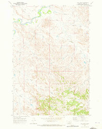
1969 Map of Jack Creek
USGS Topo · Published 1973About this map
The Tongue River winds through the northern portion of this Montana landscape, creating a wide riparian valley that contrasts with the dissected uplands to the south. Mapped from aerial photography taken in 1968, the terrain is defined by an intricate network of drainage systems, including Jack Creek, Plunket Creek, and Ash Creek. This period in Custer County's history shows a sparsely settled ranching or resource-focused environment, marked by isolated developments such as a Landing Strip and various Wells scattered across the township lines. The southern reaches are more topographically complex, where Haddow Creek and Winter Creek carve through the rising elevation toward a prominent Butte. The map serves as a precise record of water access and remote infrastructure in the high plains before further modernization altered these drainage patterns.
Find a feature on this map
12 named features on this map. Tap any name to fly to it.
Don’t see what you’re looking for? This feature index may not catch every label — zoom into the map to look around manually.
Map Details
Editions of this 1969 Jack Creek Map
This is the sole edition of this map. No revisions or reprints were ever made.
Other maps of this area

1953 · Miles City
USGS Topo · 1:250,000

1954 · Ekalaka
USGS Topo · 1:250,000

1956 · Ekalaka
USGS Topo · 1:250,000

1957 · Miles City
USGS Topo · 1:250,000

1958 · Miles City
USGS Topo · 1:250,000

1958 · Ekalaka
USGS Topo · 1:250,000

1965 · Ekalaka
USGS Topo · 1:250,000
1969 · Jack Creek NW
USGS Topo · 1:24,000

1969 · Horse Creek
USGS Topo · 1:24,000

1969 · Circle L Creek
USGS Topo · 1:24,000