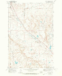
1969 Map of N Bar Coulee
USGS Topo · Published 1973About this map
North Sunday Creek meanders southeastward through this sparsely settled landscape on the border of Rosebud and Custer Counties. The geography is defined by deep drainage systems like N Bar Coulee and Owens Coulee, which cut through the high plains toward the creek beds. This 1969 field-checked survey reveals the isolated nature of the Eastern Montana cattle country, where man-made infrastructure is limited to ranching and resource extraction. Evidence of the working landscape is found at the Venn Ranch near the southern edge of the map, alongside scattered wells and a lonely Drill Hole. The primary transit corridor is the unpaved Crow Rock Road, which navigates the high ground near Hillcrest, while natural water sources like Alkali Creek and Boule Creek dictate the layout of fences and property lines in this open range.
Find a feature on this map
13 named features on this map. Tap any name to fly to it.
Don’t see what you’re looking for? This feature index may not catch every label — zoom into the map to look around manually.
Map Details
Editions of this 1969 N Bar Coulee Map
This is the sole edition of this map. No revisions or reprints were ever made.
Other maps of this area

1953 · Miles City
USGS Topo · 1:250,000

1954 · Forsyth
USGS Topo · 1:250,000

1957 · Miles City
USGS Topo · 1:250,000

1957 · Forsyth
USGS Topo · 1:250,000

1958 · Miles City
USGS Topo · 1:250,000

1958 · Forsyth
USGS Topo · 1:250,000

1968 · Big Hill
USGS Topo · 1:24,000

1968 · Butterfly Creek
USGS Topo · 1:24,000

1968 · Hathaway NW
USGS Topo · 1:24,000

1969 · Horse Creek Hill
USGS Topo · 1:24,000