
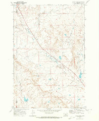
1968 Map of Hathaway NW
USGS Topo · Published 1972About this map
The Rosebud Co Custer Co line divides this northern Great Plains landscape, where the broken terrain is defined by a dendritic network of drainage systems. The northern half is dominated by the wandering path of Coal Creek and the headwaters of Sunday Creek, while the southern reaches are marked by the deeply incised valleys of Whitetail Creek and Wilson Creek. This late-1960s survey illustrates a classic Montana ranching environment, centered on the high ground around Hathaway. The presence of several named springs highlights the critical importance of reliable water sources in this semi-arid geography, where topography dictates the patterns of local travel and land use away from the primary watercourses.
Find a feature on this map
7 named features on this map. Tap any name to fly to it.
Don’t see what you’re looking for? This feature index may not catch every label — zoom into the map to look around manually.
Map Details
Editions of this 1968 Hathaway NW Map
This is the sole edition of this map. No revisions or reprints were ever made.
Other maps of this area

1954 · Forsyth
USGS Topo · 1:250,000

1957 · Forsyth
USGS Topo · 1:250,000

1958 · Forsyth
USGS Topo · 1:250,000

1968 · Sand Buttes
USGS Topo · 1:24,000

1968 · Hathaway
USGS Topo · 1:24,000

1968 · Butterfly Creek
USGS Topo · 1:24,000

1968 · Horton
USGS Topo · 1:24,000

1968 · Thurlow
USGS Topo · 1:24,000

1969 · Wild Horse Pass SE
USGS Topo · 1:24,000
1969 · N Bar Coulee
USGS Topo · 1:24,000