
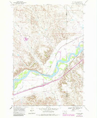
1968 Map of Hathaway
USGS Topo · Published 1972About this map
The Yellowstone River winds through this Big Sky landscape, carving a wide valley that serves as a primary corridor for transportation and history. The historic path of the Lewis and Clark Trail follows the river's southern bank, paralleling the heavy rail infrastructure of the Burlington Northern and the Chicago Milwaukee St Paul and Pacific railroads. This intersection of 19th-century exploration routes and 20th-century industrial transit defines the area's development.
Find a feature on this map
19 named features on this map. Tap any name to fly to it.
Don’t see what you’re looking for? This feature index may not catch every label — zoom into the map to look around manually.
Map Details
Editions of this 1968 Hathaway Map
2 editions found
Other maps of this area

1954 · Forsyth
USGS Topo · 1:250,000

1957 · Forsyth
USGS Topo · 1:250,000

1958 · Forsyth
USGS Topo · 1:250,000

1968 · Sand Buttes
USGS Topo · 1:24,000

1968 · Butterfly Creek
USGS Topo · 1:24,000

1968 · Horton
USGS Topo · 1:24,000

1968 · Hathaway NW
USGS Topo · 1:24,000

1968 · Thurlow
USGS Topo · 1:24,000
1969 · Moon Creek School
USGS Topo · 1:24,000
1969 · Miller Creek NW
USGS Topo · 1:24,000