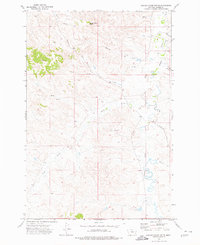
1973 Map of Saddle Horse Butte
USGS Topo · Published 1976About this map
Saddle Horse Butte stands as a prominent landmark in this Custer County landscape, overlooking a complex drainage network where Mizpah Creek meets several seasonal tributaries. The 1973 field-checked data reveals a sparse ranching environment defined by wide creek beds like Sand Creek and Deer Creek, which carve through the high plains. The presence of Anderson and the winding Powderville Road suggests the enduring routes of local transport in this part of southeastern Montana. Small-scale industrial activity is evidenced by a Gravel Pit located near the northern reaches of the Mizpah, while the terrain's numerous springs indicate the vital importance of water sources for livestock in an arid climate.
Find a feature on this map
9 named features on this map. Tap any name to fly to it.
Don’t see what you’re looking for? This feature index may not catch every label — zoom into the map to look around manually.
Map Details
Editions of this 1973 Saddle Horse Butte Map
This is the sole edition of this map. No revisions or reprints were ever made.
Other maps of this area

1953 · Miles City
USGS Topo · 1:250,000

1954 · Ekalaka
USGS Topo · 1:250,000

1956 · Ekalaka
USGS Topo · 1:250,000

1957 · Miles City
USGS Topo · 1:250,000

1958 · Miles City
USGS Topo · 1:250,000

1958 · Ekalaka
USGS Topo · 1:250,000

1965 · Ekalaka
USGS Topo · 1:250,000

1969 · Forty Creek
USGS Topo · 1:24,000

1969 · Miles City Creek
USGS Topo · 1:24,000
1969 · Beebe
USGS Topo · 1:24,000