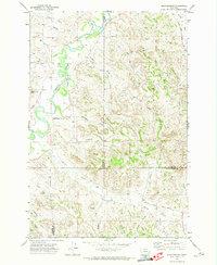
1971 Map of Brandenberg
USGS Topo · Published 1974About this map
The Tongue River meanders through a landscape defined by sharp coulees and high buttes at the border of Rosebud, Custer, and Powder River Counties. The small settlement of Brandenberg serves as the primary landmark in this region of eastern Montana, situated where the river bottom meets the rising terrain. Ranching and land management are evident through the network of drainage-aligned roads like Beaver Creek Road and several noted wells and gravel pits scattered across the hills.
Find a feature on this map
33 named features on this map. Tap any name to fly to it.
Don’t see what you’re looking for? This feature index may not catch every label — zoom into the map to look around manually.
Map Details
Editions of this 1971 Brandenberg Map
This is the sole edition of this map. No revisions or reprints were ever made.
Other maps of this area

1954 · Hardin
USGS Topo · 1:250,000

1957 · Hardin
USGS Topo · 1:250,000

1958 · Hardin
USGS Topo · 1:250,000

1966 · Beaver Creek School
USGS Topo · 1:24,000

1966 · Cook Creek Reservoir
USGS Topo · 1:24,000

1966 · Ashland NE
USGS Topo · 1:24,000
1971 · Brandenberg NW
USGS Topo · 1:24,000

1971 · Hammond Draw
USGS Topo · 1:24,000
1971 · Hayes Point
USGS Topo · 1:24,000
1971 · HS School
USGS Topo · 1:24,000