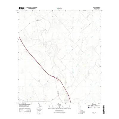
2016 Map of McCoy
USGS Topo · Published 2016About this map
The Atascosa River winds through the heart of this South Texas landscape, defining the corridor between the settlements of McCoy to the north and Campbellton to the south. This area of Atascosa County is characterized by a dense network of intermittent creeks, including Buckhorn Cr, Borrego Cr, and Lipan Cr, which drain into the river valley. The landscape is dotted with small bodies of water such as Goose Lake and Big Lake, reflecting the region's ranching and agricultural foundations. Transportation is anchored by the modern I-37 corridor and older routes like FM 541 and FM 140. Local landmarks such as the Campbellton Cem and the Arrow 's Ranch Airport provide specific points of interest for genealogists and local historians tracking family landholdings and community development in this rural Texas quadrangle.
Find a feature on this map
29 named features on this map. Tap any name to fly to it.
Don’t see what you’re looking for? This feature index may not catch every label — zoom into the map to look around manually.
Map Details
Editions of this 2016 McCoy Map
This is the sole edition of this map. No revisions or reprints were ever made.
Other maps of this area

1930 · Whitsett
USGS Topo · 1:62,500

1931 · Falls City
USGS Topo · 1:62,500

1942 · Whitsett
USGS Topo · 1:62,500

1953 · Crystal City
USGS Topo · 1:250,000

1955 · Crystal City
USGS Topo · 1:250,000

1956 · Suniland
USGS Topo · 1:62,500

1956 · Pleasanton
USGS Topo · 1:62,500

1961 · Crystal City
USGS Topo · 1:250,000
1961 · Three Oaks
USGS Topo · 1:24,000
1961 · Fashing
USGS Topo · 1:24,000