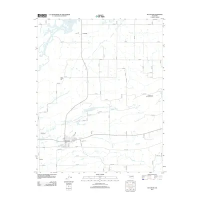
2012 Map of McCurtain
USGS Topo · Published 2012About this map
McCurtain serves as the primary hub of this eastern Oklahoma landscape, where a grid of local streets like Nelson Ave and Cole St meets the rural road network. The terrain is defined by a dense system of waterways including Mule Creek, Wildhorse Creek, and Owl Creek, which feed toward the northern edge where the Robert S Kerr Reservoir dominates the horizon. Topographical highlights such as Seven Devils Mtn and Spring Mountain rise above the drainage basins, providing distinctive landmarks for the area's geography. Smaller settlements like Ironbridge and Panther are situated along the transit corridors, while the presence of the Iron Bridge Cem and Garden of Memories Cem provides specific points of interest for genealogists tracing local family histories. The interplay between the managed waters of Club Lake and the natural flow of Sans Bois Creek reflects the region's hydraulic character.
Find a feature on this map
44 named features on this map. Tap any name to fly to it.
Don’t see what you’re looking for? This feature index may not catch every label — zoom into the map to look around manually.
Map Details
Editions of this 2012 McCurtain Map
This is the sole edition of this map. No revisions or reprints were ever made.
Other maps of this area

1900 · Sansbois
USGS Topo · 1:125,000

1900 · Sallisaw
USGS Topo · 1:125,000

1909 · Sans Bois
USGS Topo · 1:125,000

1911 · Sallisaw
USGS Topo · 1:125,000

1911 · Sansbois
USGS Topo · 1:125,000

1946 · Fort Smith
USGS Topo · 1:250,000

1962 · Stigler East
USGS Topo · 1:24,000

1965 · Fort Smith
USGS Topo · 1:250,000

1967 · Fort Smith
USGS Topo · 1:250,000
1967 · Keota
USGS Topo · 1:24,000