
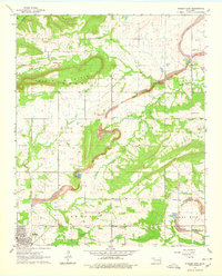
1962 Map of Stigler East
USGS Topo · Published 1964About this map
The rugged topography of Morgan Mountain and Taloka Mountain dominates this Haskell County landscape in the early 1960s. The area reveals a mix of rural agriculture and extractive industry, with significant Mines and a notable Strip Mine located in the southwestern reaches of the Sans Bois region. The city of Stigler anchors the southwest corner of the sheet, where a local Substation and a nearby Fish Hatchery mark the local utility and conservation infrastructure.
Find a feature on this map
24 named features on this map. Tap any name to fly to it.
Don’t see what you’re looking for? This feature index may not catch every label — zoom into the map to look around manually.
Map Details
Editions of this 1962 Stigler East Map
2 editions found
Other maps of this area

1900 · Sansbois
USGS Topo · 1:125,000

1900 · Sallisaw
USGS Topo · 1:125,000

1909 · Sans Bois
USGS Topo · 1:125,000

1911 · Sallisaw
USGS Topo · 1:125,000

1911 · Sansbois
USGS Topo · 1:125,000

1946 · Fort Smith
USGS Topo · 1:250,000

1962 · Stigler West
USGS Topo · 1:24,000
1963 · Stigler NE
USGS Topo · 1:24,000
1963 · Holt Mountain
USGS Topo · 1:24,000
1964 · Stigler NE
USGS Topo · 1:24,000