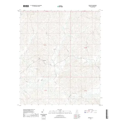
2020 Map of McEntyre
USGS Topo · Published 2020About this map
McEntyre sits at the heart of this Clarke County landscape, where the terrain is defined by a dense network of creek valleys and ridges. The settlement pattern is largely dictated by the winding path of Harris Cr and Wells Cr, with small family and community burial grounds like Huggins Cem and New Prospect Cem serving as primary genealogical landmarks. The road network, including Nicco Rd and Otis Hare Rd, connects isolated homesteads across the drainage basins of Salitpa Cr and Morgan Cr. This 2020 data captures a rural Alabama interior that has maintained its character for decades, with property boundaries still following the Public Land Survey System established in the 19th century. Researchers will find interest in the placement of Bell-Brewer Cem and Oak Grove Cem, which anchor the small population centers throughout the northern and southern reaches of the quadrangle.
Find a feature on this map
34 named features on this map. Tap any name to fly to it.
Don’t see what you’re looking for? This feature index may not catch every label — zoom into the map to look around manually.
Map Details
Editions of this 2020 McEntyre Map
This is the sole edition of this map. No revisions or reprints were ever made.
Other maps of this area

1953 · Andalusia
USGS Topo · 1:250,000

1953 · Hattiesburg
USGS Topo · 1:250,000

1957 · Andalusia
USGS Topo · 1:250,000

1958 · Hattiesburg
USGS Topo · 1:250,000

1971 · Coffeeville
USGS Topo · 1:24,000

1972 · Tattlersville
USGS Topo · 1:24,000

1972 · Woods Bluff
USGS Topo · 1:24,000

1978 · McEntyre
USGS Topo · 1:24,000
1978 · Bashi
USGS Topo · 1:24,000

1978 · Winn
USGS Topo · 1:24,000